Showing 760 items matching subdivision of land
-
![Planning Document, Plan of proposed subdivision of land in Greensborough [Map shows Scotland house], 01/04/1971](https://victoriancollections.net.au/media/collectors/4f729f5697f83e03086015b8/items/5982a68921ea6b1420e4e560/item-media/59916fb521ea681094908d7a/item-fit-380x285.jpg) Greensborough Historical Society
Greensborough Historical SocietyPlanning Document, Plan of proposed subdivision of land in Greensborough [Map shows Scotland house], 01/04/1971
... Plan of proposed subdivision of land in Greensborough [Map... subdivision of land in Greensborough [Map shows Scotland house ...This subdivision of Greensborough shows the home of John Scotland (died 1888) and surrounding area bounded by Hailes, William, Lorimer, and Jessop Streets.Photocopy of plan, 2 pages.Part of plan (68G) of proposed subdivision of Greensborough, part of Crown Portion 18, Parish pf Keelbundora. Scale: 132 ft. to an inchjohn scotland, hailes street greensborough, william street greensborough, lorimer street greensborough, jessop street greensborough -
 Ringwood and District Historical Society
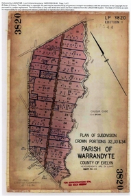
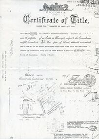
Document, Titles of land subdivision, Crown Portions 32, 33 & 34, Parish of Warrandyte, 1884 and 1907, Ringwood, Victoria
... Titles of land subdivision, Crown Portions 32, 33 & 34...Evolution of the subdivision and the use of land...Document Titles of land subdivision, Crown Portions 32, 33 ...Evolution of the subdivision and the use of landBlack plastic bound pockets containing copies of 18 LANDATA subdivision maps and mortgage transfer pages dating from 1884 for 303 acres 2 roods and 1 perch bounded by Warrandyte Road, Wonga Road, Oban Road and Mullum Mullum Creek in Ringwood, Victoria. Certificates of Title include Vol 1606 Fol 045 Frederick Walter Purches 1884 and subsequent transfers to 1902, and Vol 3232 Fol 646357 Ann Jane Kennedy 1907 and transfers to 1921. -
 Ringwood and District Historical Society
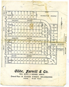
Document, Glen Turnbull, Land Sale Brochure - Heathmont Hills Estate - subdivision of Stan Wieland's Land (undated), 25/2/2008
... Land Sale Brochure - Heathmont Hills Estate - subdivision... - subdivision of Stan Wieland's Land (undated) Small brochure by Glide ...Small brochure by Glide Farrell & Co, real estate and Business Agents, Melbourne advertising "93 Superb Building Blocks 3Mins Station & Shops", and "Sky-Line Views of Heathmont Hills Estate" , comprising lots in Dresden Ave, Doulton Ave, Devon Ave, Viviana Crescent, Leoni Avenue. -
 Ringwood and District Historical Society
Envelope, Nunawading, Ringwood, East Ringwood Land Subdivision Sales, and Grid Map of Melbourne
... Nunawading, Ringwood, East Ringwood Land Subdivision Sales...Land Subdivision Sales - Nunawading; Land Subdivision Sales..., East Ringwood Land Subdivision Sales, and Grid Map of Melbourne ...Land Subdivision Sales - Nunawading; Land Subdivision Sales - East Ringwood; Land Subdivision Sales - Ringwood; Land Subdivision Sales - Grid map of Melbourne -
Whitehorse Historical Society Inc.
Document, Canterbury Road estate, Unknown
... land subdivision...Plan of subdivision of land for sale in Canterbury Road... of subdivision of land for sale in Canterbury Road estate, Blackburn ...Plan of subdivision of land for sale in Canterbury Road estate, Blackburn.land subdivision, canterbury road estate, blackburn, main street, norvel street, kalka street, arna street, lalwa street, ronley street, eustace street -
City of Moorabbin Historical Society (Operating the Box Cottage Museum)
Document - Tenth Anniversary - Presbyterian Church East Bentleigh, 1957 - 1967, 1967
... subdivision of land... subdivision of land religion ...Presbyterian Church East Bentleigh, built in 1957 in Cecil Street East Bentleigh. The site and building is now (2022) being used by Chabad, Bentleigh, which serves to cater to the needs of the Jewish Community.Presbyterian Church Bentleigh was formed to cater for the growing population of Bentleigh when the market gardens were subdivided into residential blocks.Document with blue cover, 18 pages. Contains text and pictures.parish of moorabbin, city of moorabbin, county of bourke, shire of moorabbin, market gardeners, presbyterian church east bentleigh, cecil street, east bentleigh, subdivision of land, religion -
Whitehorse Historical Society Inc.
Article, Too many industries, 1990
... Land subdivision...Article about subdivision of land of Wunderlich Monier... about subdivision of land of Wunderlich Monier, showing ...Article about subdivision of land of Wunderlich Monier, showing that this would increase the number of industries in the area.Article about subdivision of land of Wunderlich Monier, showing that this would increase the number of industries in the area.Article about subdivision of land of Wunderlich Monier, showing that this would increase the number of industries in the area.land subdivision, mitcham road vermont, rooks road vermont, wunderlich limited -
 Whitehorse Historical Society Inc.
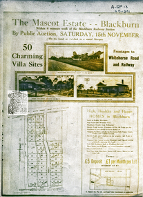
Document, Mascot Estate Blackburn
... land subdivision...Subdivision of land surrounded by Whitehorse Road, Simla... Subdivision of land surrounded by Whitehorse Road, Simla street ...Subdivision of landSubdivision of land surrounded by Whitehorse Road, Simla street and King Street. 50 villa sites auctioned by M.Pullyn & Frank FisherSubdivision of land land subdivision, mascot estate blackburn, whitehorse road, blackburn, iona street, king street, simla street, pullyn, m, frank fisher & co. -
 Whitehorse Historical Society Inc.
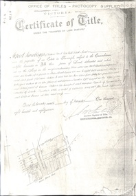
Document - Land Title, Certificate of Title, 29/11/1887
... land subdivision...Photocopies of land titles involved in subdivision of land... Photocopies of land titles involved in subdivision of land ...Photocopies of land titles involved in subdivision of land on the north-west corner of Whitehorse Road and Mitcham Road including Britannia Street. A list of purchasers is included.mitcham road, mitcham, whitehorse road, britannia street, rawlings, alfred, frost, john, richards, thomas, leech, george arthur, smith, reed, richard louis, young, frederick, hughes, doery, george henry, mitcham primary school, no. 2904, land subdivision -
 Kew Historical Society Inc
Plan - Subdivision Plan, Cotham Vale Estate, 1919
... the periods of urban development and subdivisions of land in Kew...The Cotham Vale Estate was a subdivision of land between... was a subdivision of land between Alfred, Thomas, Rowland and John Streets ...Pru Sanderson, in her groundbreaking ‘City of Kew Urban Conservation Study : Volume 2 - Development History’ (1988), summarised the periods of urban development and subdivisions of land in Kew. The periods that she identified included 1845-1880, 1880-1893, 1893-1921, 1921-1933, 1933-1943, and Post-War Development. These periods were selected as they represented periods of rapid growth or decline in urban development. An obvious starting point for Sanderson’s groupings involved population growth and the associated economic cycles. These cycles also highlighted urban expansion onto land that was predominantly rural, although in other cases it represented the decline and breakup of large estates. A number of the plans in the Kew Historical Society’s collection can also be found in other collections, such as those of the State Library of Victoria and the Boroondara Library Service. A number are however unique to the collection.The Kew Historical Society collection includes almost 100 subdivision plans pertaining to suburbs of the City of Melbourne. Most of these are of Kew, Kew East or Studley Park, although a smaller number are plans of Camberwell, Deepdene, Balwyn and Hawthorn. It is believed that the majority of the plans were gifted to the Society by persons connected with the real estate firm - J. R. Mathers and McMillan, 136 Cotham Road, Kew. The Plans in the collection are rarely in pristine form, being working plans on which the agent would write notes and record lots sold and the prices of these. The subdivision plans are historically significant examples of the growth of urban Melbourne from the beginning of the 20th Century up until the 1980s. A number of the plans are double-sided and often include a photograph on the reverse. A number of the latter are by noted photographers such as J.E. Barnes.The Cotham Vale Estate was a subdivision of land between Alfred, Thomas, Rowland and John Streets. It was promoted in the same time as the nearby Normanby Heights Estate. Cotham Vale included 28 allotments. Contemporary newspaper advertisements noted that the Estate ‘is most conveniently situated in a well elevated position, only 2 minutes from Cotham rd. Electric Cars, penny section to Kew station’.subdivision plans - kew, cotham vale estate, rowland street -- kew (vic.), thomas street -- kew (vic.), john street -- kew (vic.) -
 Ringwood and District Historical Society
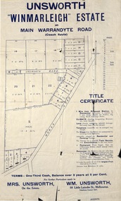
Flyer, Land Sale Advertisement - Unsworth Winmarleigh Estate, Ringwood, Victoria - circa 1912
... Advertisement and attachment for subdivision of land... Advertisement and attachment for subdivision of land adjoining ...Advertisement and attachment for subdivision of land adjoining Warrandyte Road coach route in North Ringwood, with map showing layout of subdivision, summary of local features and services, and terms of sale. Subdivision includes Wonga Road (later Loughnan Road & Warrandyte Road), Unsworth Road, Through Road, Cross Street, and John Street. Contacts - Mrs Unsworth on the Estate or W.M. Unsworth, 58 Little Latrobe Street, Melbourne, Telephone Central 7207. -
 Whitehorse Historical Society Inc.
Document, Land purchase Certificate of Title, 12/11/1913 12:00:00 AM
... Plan of subdivision of land in the Shire of Nunawading... of Title Plan of subdivision of land in the Shire of Nunawading ...Plan of subdivision of land in the Shire of Nunawading which includes 'Wandinong'.Plan of subdivision of land in the Shire of Nunawading which includes 'Wandinong'. Copy of Certificate of Title of Crown Grant to Janet Emily Hooke, nee Billing, dated 12/11/1913, also purchase of land by J. Woods dated 31/3/1856.Plan of subdivision of land in the Shire of Nunawading which includes 'Wandinong'. haines, william, woods, john, hooke, janet emily, billing, wandinong sanctuary, canterbury road, blackburn, blackburn road -
 Greensborough Historical Society
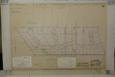
Planning document, Subdivision Plan #1009. Corner Allumba Drive and Beales Road Greensborough, 1981_
... Plan of Subdivision of land at corner of Allumba Drive... Plenty Lower Plenty melbourne Planning document Subdivision Plan ...Plan of Subdivision of land at corner of Allumba Drive and Beales Road Greensborough.An example of hard copy subdivision plans from the Greensborough area. Mainly from the Shire of Diamond Valley era (1964-1994).Plan (2 sheets) mounted on heavy card.Stamped and handwritten Council permissions, dates and other details.subdivision plans, allumba drive, beales road -
Whitehorse Historical Society Inc.
Map, Subdivision of Allotment 122a, 1972
... Land Subdivision...Subdivision of land along Livermore Close and Moore Road... Subdivision of land along Livermore Close and Moore Road, Vermont ...Subdivision of land along Livermore Close and Moore Road, Vermont South.Subdivision of land along Livermore Close and Moore Road, Vermont South. Original survey Rob Poole 1899. Stamp indicates 'Land on this plan is in proclaimed survey No 21. Survey Coordination Act 1940. As from 9 Aug 1972. Two maps in different scales.Subdivision of land along Livermore Close and Moore Road, Vermont South. land subdivision, livermore close, vermont south, moore road, vermont south, dandenong creek -
 Greensborough Historical Society
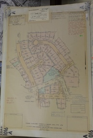
Planning Document, Subdivision Plan # 1016. Corner Weidlich and St Clems Roads Greensborough, 05/10/1981
... Plan of Subdivision of land at corner of Weidlich Road... permissions, dates and other details. Plan of Subdivision of land ...Plan of Subdivision of land at corner of Weidlich Road and St Clems Road Greensborough.Plan (2 sheets) mounted on heavy card.Stamped and handwritten Council permissions, dates and other details.subdivision plans, weidlich road -
Whitehorse Historical Society Inc.
Article, A win for all in give and take, 1990
... Land subdivision... between land developers and residents of Vermont over subdivision... land developers and residents of Vermont over subdivision ...Article about the conclusion reached through negotiation between land developers and residents of Vermont over subdivision of Wunderlich landArticle about the conclusion reached through negotiation between land developers and residents of Vermont over subdivision of Wunderlich landArticle about the conclusion reached through negotiation between land developers and residents of Vermont over subdivision of Wunderlich landrooks road vermont, mitcham road vermont, land subdivision, wunderlich limited -
 Whitehorse Historical Society Inc.
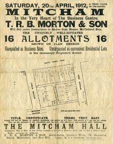
Document, Mitcham Hall, 1912
... land subdivision...Advertising poster relating to the Subdivision of land... poster relating to the Subdivision of land surrounded by Mitcham ...Subdivision of landAdvertising poster relating to the Subdivision of land surrounded by Mitcham Station, Station Street, Whitehorse Road and Mitcham Road, for sale by auction Saturday 20th April 1912 under instructions from Messrs. McLelland Bros.. Also the sale of Mitcham Hall. Auctioneers T.R.B. Morton, Melbourne and Box Hill. Hall used by Girl Guides until its demolition in 1988.Subdivision of land mitcham hall, land subdivision, t. r. b. morton & son, station street mitcham, mitcham road, mitcham, whitehorse road mitcham, mclelland bros. -
![Monnington [Estate], 1935](https://victoriancollections.net.au/media/collectors/550653872162f11fb04854aa/items/5907eb86d0ce0c14e82385c8/item-media/5907ecafd0ce0c14e823e87f/item-fit-380x285.jpg) Kew Historical Society Inc
Kew Historical Society IncPlan - Subdivision Plan, Monnington [Estate], 1935
... the periods of urban development and subdivisions of land in Kew...The first subdivision of Monnington took place in 1935... for sale. The subdivision created the irregular land holding ...Pru Sanderson, in her groundbreaking ‘City of Kew Urban Conservation Study : Volume 2 - Development History’ (1988), summarised the periods of urban development and subdivisions of land in Kew. The periods that she identified included 1845-1880, 1880-1893, 1893-1921, 1921-1933, 1933-1943, and Post-War Development. These periods were selected as they represented periods of rapid growth or decline in urban development. An obvious starting point for Sanderson’s groupings involved population growth and the associated economic cycles. These cycles also highlighted urban expansion onto land that was predominantly rural, although in other cases it represented the decline and breakup of large estates. A number of the plans in the Kew Historical Society’s collection can also be found in other collections, such as those of the State Library of Victoria and the Boroondara Library Service. A number are however unique to the collection.Subdivision plans are historically important documents used as evidence of the growth of suburbs in Australia. They frequently provide information about when the land was sold on which a built structure was subsequently constructed as well as evidence relating to surveyors and real estate and financial agents. The numerous subdivision plans in the Kew Historical Society's collection represent working documents, ranging from the initial sketches made in planning a subdivision to printed plans on which auctioneers or agents listed the prices for which individual lots were sold. In a number of cases, the reverse of a subdivision plan in the collection includes a photograph of a house that was also for sale by the agent. These photographs provide significant heritage information relating house design and decoration, fencing and household gardens.The first subdivision of Monnington took place in 1935. At that time, Monnington and 10 new allotments were offered for sale bordering Adeney and Marshall Avenues. In this subdivision plan, Monnington is one of 13 lots for sale. The subdivision created the irregular land holding of Monnington today. The excision of southwest corner of Monninton was caused by the need to have regular allotments facing the curve in Marshall Avenue.monnington - adeney avenue -- kew (vic.), subdivision plans -- kew (vic.) -
Port Melbourne Historical & Preservation Society
Plan - Subdivision of area bounded by Nott Street, Rouse Street, Beach Street, Port Melbourne, Block Number 2067, 1884
... , Beach Street, showing subdivision of land with relevant property..., Rouse Street, Beach Street, showing subdivision of land ...Copy of plan of area bordered by Nott Street, Rouse Street, Beach Street, showing subdivision of land with relevant property owners (HB DONALDSON, J NOLAN, J Hill and Sons, GW ROBINS, Carl ECKBURG, JM SMITHSON, J WALLACE) Block number 1, Port Melbourne 1884, Block number 20.67. Water Mark on Paper "J Whatman 1883"built environment - domestic, j whatman, henry beveridge donaldson, j nolan, j hill and sons, g w robins, carl eckburg, j m smithson, j wallace -
Glen Eira Historical Society
Document - Vadlure Avenue, 2, St. Kilda East
... subdivision of land formerly grounds of Kilwinning and residents... East Service James Land Subdivisions 'Kilwinning' Denman Street ...Printed and handwritten research from Brighton Historical Society giving brief details on 2 Vadlure Avenue, regarding subdivision of land formerly grounds of Kilwinning and residents of property from 1931 to 1974. Dated 19/01/1988.vadlure avenue, st. kilda east, service james, land subdivisions, 'kilwinning', denman street, kosky samuel, mcardle daniel j., elisha e., elisha d., bullock h., landells rosalind -
 Greensborough Historical Society
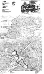
Map, Dennis Ward, John Batman's 1835 Treaty Trail on the Plenty River, 2010_
... Large laminated map, including land subdivisions and street... on the Plenty River Large laminated map, including land subdivisions ...Map of the Plenty River through Greensborough and surrounding areas, annotated with historic places. Prepared by Dennis Ward, this map shows places of interest with historic markers for a proposed Heritage Trail along the Plenty. This was a joint project of Dennis Ward, Rotary Greensborough and Nillumbik Historical Society.This map shows many places of interest along the Plenty River. Large laminated map, including land subdivisions and street names.plenty river heritage trail -
Whitehorse Historical Society Inc.
Article, Council rules for land subdivisions, 1976
... Land subdivision...'Know your Council' stating rules and procedures for land... subdivisions 'Know your Council' stating rules and procedures for land ...'Know your Council' stating rules and procedures for land subdivision.'Know your Council' stating rules and procedures for land subdivision.'Know your Council' stating rules and procedures for land subdivision.city of nunawading, land subdivision -
Tatura Irrigation & Wartime Camps Museum
Poster, Subdivision of Township Allotments
... land subdivision... of land subdivision.... of land subdivision. Poster depicting the land which was being ...Poster depicting the land which was being sold by J S Darby on the 3 December 1890. Auctioneer was Martin Cussen and Co. Map shows location of land.Single sheet of paper, laminated. Advertising land subdivision for sale in the township of Rushworth. Being sold by Martin Cussen and Co, auctioneers for J S Darby. Shows map of land subdivision.rushworth, land subdivision, martin cussen and co, j s darby -
 Ringwood and District Historical Society
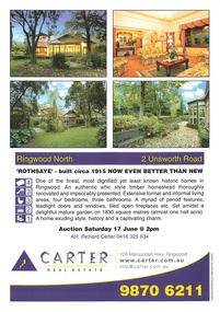
Memorabilia - Property History, Rothsaye, 2 Unsworth Road Ringwood North, Victoria
... pages of the property history, subdivisions, land titles... binder containing 34 pages of the property history, subdivisions ..."Rothsaye" was built in 1917 by J.B. McAlpin who was a councillor in Lillydale and Ringwood and was Mayor in 1928-29.Multi pocket burgundy coloured spiral binder containing 34 pages of the property history, subdivisions, land titles and photographs of the house, compiled by Richard Carter pre-auction 17 June 2006 -
 Kew Historical Society Inc
Plan - Subdivision Plan, High Street, Kew, 1920-1935
... the periods of urban development and subdivisions of land in Kew...A roughly drawn and faded actual or projected subdivision... actual or projected subdivision of a parcel of land bordering ...Pru Sanderson, in her groundbreaking ‘City of Kew Urban Conservation Study : Volume 2 - Development History’ (1988), summarised the periods of urban development and subdivisions of land in Kew. The periods that she identified included 1845-1880, 1880-1893, 1893-1921, 1921-1933, 1933-1943, and Post-War Development. These periods were selected as they represented periods of rapid growth or decline in urban development. An obvious starting point for Sanderson’s groupings involved population growth and the associated economic cycles. These cycles also highlighted urban expansion onto land that was predominantly rural, although in other cases it represented the decline and breakup of large estates. A number of the plans in the Kew Historical Society’s collection can also be found in other collections, such as those of the State Library of Victoria and the Boroondara Library Service. A number are however unique to the collection.The Kew Historical Society collection includes almost 100 subdivision plans pertaining to suburbs of the City of Melbourne. Most of these are of Kew, Kew East or Studley Park, although a smaller number are plans of Camberwell, Deepdene, Balwyn and Hawthorn. It is believed that the majority of the plans were gifted to the Society by persons connected with the real estate firm - J. R. Mathers and McMillan, 136 Cotham Road, Kew. The Plans in the collection are rarely in pristine form, being working plans on which the agent would write notes and record lots sold and the prices of these. The subdivision plans are historically significant examples of the growth of urban Melbourne from the beginning of the 20th Century up until the 1980s. A number of the plans are double-sided and often include a photograph on the reverse. A number of the latter are by noted photographers such as J.E. Barnes.A roughly drawn and faded actual or projected subdivision of a parcel of land bordering on High and Mary Streets. The plan shows five allotments facing High Street and at their rear, another allotment facing Mary Street. In 1906, when the Board of Works surveyors completed Detail Plan 1589, the allotment in Mary Street is shown to include a building. The section of land attached to this building is shown to be undeveloped, thus making a further subdivision possible.subdivision plans - kew, high street -- kew (vic.), mary street -- kew (vic.) -
 Lake Bolac & District Historical Society
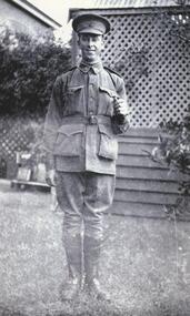
Black and white photograph, Gunner Stanley Herbert Moreton, Field Artillery Brigade, WW1
... '. After WW2 Stanley was involved in helping with the subdivision... was involved in helping with the subdivision of land for soldier ...Gunner Stanley Herbert Moreton, enlisted 04/12/1916 in a Field Artillery Unit. He embarked for France on 11/05/1917. Upon his return from the war, he purchased 'Parupa Park'. After WW2 Stanley was involved in helping with the subdivision of land for soldier settlement. He died in 1978 at the age of 85.moreton, field artillery unit, 'parupa park', soldier settlement, -
Canterbury History Group
Map - Canterbury Subdivisions
... and dates of land subdivision in Canterbury and surrounding suburbs.... with notations showing the names and dates of land subdivision ...A collection of 6 maps with notations showing the names and dates of land subdivision in Canterbury and surrounding suburbs.canterbury, logans estate, shrublands estate, claremount park estate, arklow hill estate, griffin estate, monomeath estate, mont albert park estate, great railway estate, grange estate -
Whitehorse Historical Society Inc.
Newspaper - Article, Residents fear for streetscape, 28/09/1994
... Land Subdivision...,' (Walker home), Meerut Street, Mitcham, land subdivision opposite....), Meerut Street, Mitcham, land subdivision opposite. Meerut Street ...'Residents fear for streetscape' ' Mitcham Mansion,' (Walker home), Meerut Street, Mitcham, land subdivision opposite.meerut street, mitcham, walker, edgar edwardes, australian tesselated tile co pty ltd, barelli, ken, land subdivision -
 Warrnambool and District Historical Society Inc.
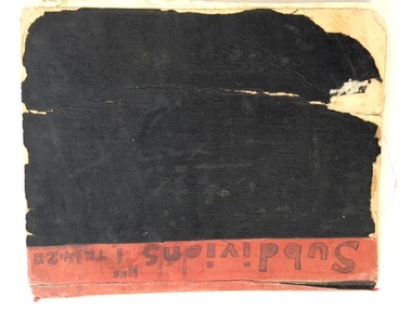
Book, Subdivision No 1 to 1420, 1930s
... in 1918. Subdivisions of land in the city continue to be made... in 1883 and a City in 1918. Subdivisions of land in the city ...This is an exercise book listing subdivisions in Warrnambool from 1935 to 1977. There are 1420 entries. It gives details of the subdivisions – plan number, street, section number, allotment number, date, owner, solicitor and Titles Office number. The book is completely filled and today this information would be held in the Warrnambool City Council offices per electronic data storage. Warrnambool, founded in 1847, became a Municipality in 1856, a Borough in 1863, a Town in 1883 and a City in 1918. Subdivisions of land in the city continue to be made regularly for housing and business purposes.This book is of great historic interest because it details the subdivisions in the City of Warrnambool from 1935 to 1977. It shows the continuing growth of the city, particularly after World War Two. It will be a very useful resource for researchers. This is an exercise book with a black cardboard cover and red binding. It contains a list of City of Warrnambool subdivisions from 1935 to 1977. The cover and some of the pages are torn and ragged and the binding has come apart and has been glued together in places. The pages are ruled with blue and red lines. The pages contain handwritten material in black and blue ink. Front Cover: ‘Subdivions(sic), Nos 1 to 1420’ Inside Front Cover: ‘City of Warrnambool Subdivisions’ warrnambool city council, warrnambool subdivisions -
 Whitehorse Historical Society Inc.
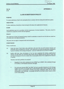
Document, Land Subdivision Policy, 24/08/1998 12:00:00 AM
... Land Subdivision Policy...land subdivision...Land subdivision policy: approved by City... Mitcham melbourne Document Document Land Subdivision Policy Land ...Land subdivision policyLand subdivision policy: approved by City of Whitehorse.Ordinary council meeting 24/8/1998, Item 12.1.5 p. 42-43Land subdivision policyland subdivision, city of whitehorse